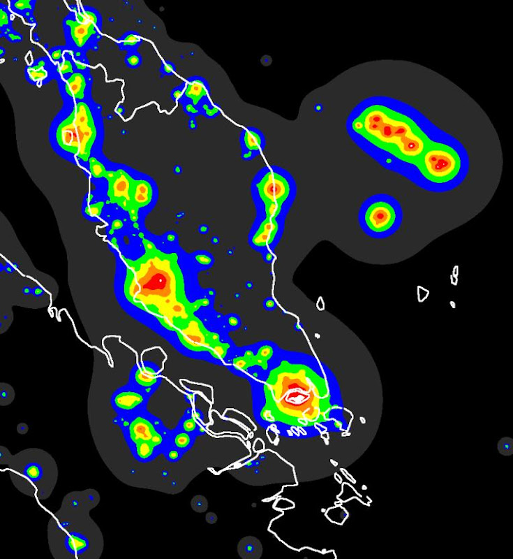
For those searching for ob sites in West Malaysia, I think the implications of this light pollution map can be quite useful:
1. The east coast is generally darker then the west.
2. If we are looking for the best darksky-per-distance-travelled, Johor is still the best bet.
3. Assuming all other things being the same (e.g. mist/dew issues, creature comforts, ..etc) there is no significant darker sky advantage in travelling all the way up north since it is still represented by the same light grey patch, compared to the darkest black areas in Sumatra and its off-shore islands to the south of Singapore.
Feel free to share your thoughts on these implications.
"The importance of a telescope is not how big it is, how well made it is.
It is how many people, less fortunate than you, got to look through it."
-- John Dobson.
I recall Yiren had at one time superimposed this map, from the Italian website, onto a road map of Malaysia on his website.
Although this map does give a good overall sense of light pollution in Malaysia / S'pore, I think it is a bit too broad in scale.
Personally I prefer the light pollution map on Google Earth, which is much more detailed and even shows light pollution domes from small towns. Further, one can switch between the satellite photo view (showing roads, buildings, street names etc), and the light pollution view.
Specifically, I think the light grey patch in the above map does not sufficiently differentiate between moderately dark and much darker places.
Anyway, I suspect that both versions are quite out of date, by around 5-12 years, and there has been quite a lot of increased lighting in recent years, esp in Johor.
So I agree with point no. 1, but am not so sure about point nos. 2 and 3 as I think that this map is not detailed enough. I have begun to think that we may now have to go to Pahang for truly darker skies. Does anyone know of a good obs location there? Or is there some special place in Johor still to be found?
Nevertheless, these maps are certainly good starting points to hunt for potential sites. Let's start the recce trips!
PS: If one wishes to avoid depression, then do not look at the light pollution map of Australia. For example, the areas just north and east of Perth. Envy them! Plus, no border crossings needed too.
The islands south of Singapore are P. Singkep and Lingga.
Unfortunately those are reachable only by ferry transfer from Bintan and service is not very frequent. Also the landing is a challenge if you have heavy equipment...
"The importance of a telescope is not how big it is, how well made it is.
It is how many people, less fortunate than you, got to look through it."
-- John Dobson.